
Yosemite National Park is on many people’s bucket list, but it can be overwhelming to try to plan a trip to such a large park that is also incredibly busy. Check out my guide below with tips for visiting Yosemite, hiking in Yosemite, and where to stay.

Vernal Falls
Yosemite Tips:
If you’re visiting during peak season (mid-May-September) you will need a reservation to enter the park. Learn more and book your reservation here. If you do not have a reservation you can enter the park before 6am or after 4pm.
You will also need either a National Park Pass or to pay $35 for 3 days of access to enter the park.
I cannot emphasize this enough: start your days early. You will avoid crowds, parking issues, and the heat if you just set that alarm a little bit earlier and get moving early.
If you enjoy waterfalls, visit during the spring or early summer when they are the most active. The snowmelt creates an abundance of water.
I would also recommend that you get out of Yosemite Valley. Many people who visit the park only visit the Valley which is the most touristy area. There are 6 distinct areas to Yosemite: Yosemite Valley, Hetch Hetchy, Glacier Point, Wawona and Mariposa Grove, and Tuolumne Meadows.
While in Yosemite Valley there is a convenient and free shuttle to take you to different points without having to move your car. If you are staying at certain locations in the park this is also a great option for getting around the Valley. There are two different shuttle loops that operate about every 10-20 minutes—learn more here.
You can also bike in Yosemite Valley via the bike rental shop and bike lanes are everywhere.
Tioga Pass Road cuts through the center of the park and is only open seasonally. Each year it differs depending on conditions, but it is generally open late May through September. Many hikes and lakes are along this road, so be sure to plan ahead.
Be bear aware! All of the bears in Yosemite are black bears, so if you see them in the wild keep your distance, if you see them in a public space get as large and loud as possible. Do not leave food in your car and always have your backpack within reach. Drive the speed limit throughout the park to save bears.
If you are visiting in the year 2022 Glacier Point and Glacier Point Road will remain closed all year. Any trails along the road are inaccessible and Glacier Point, a popular viewpoint, is inaccessible. Bridalveil Falls is also closed for 2022.
A note, Crane Flat Lookout Trail is not a trail, despite what AllTrails thinks. It’s a road to a fire tower which you actually can’t even go up for views. You’re welcome!
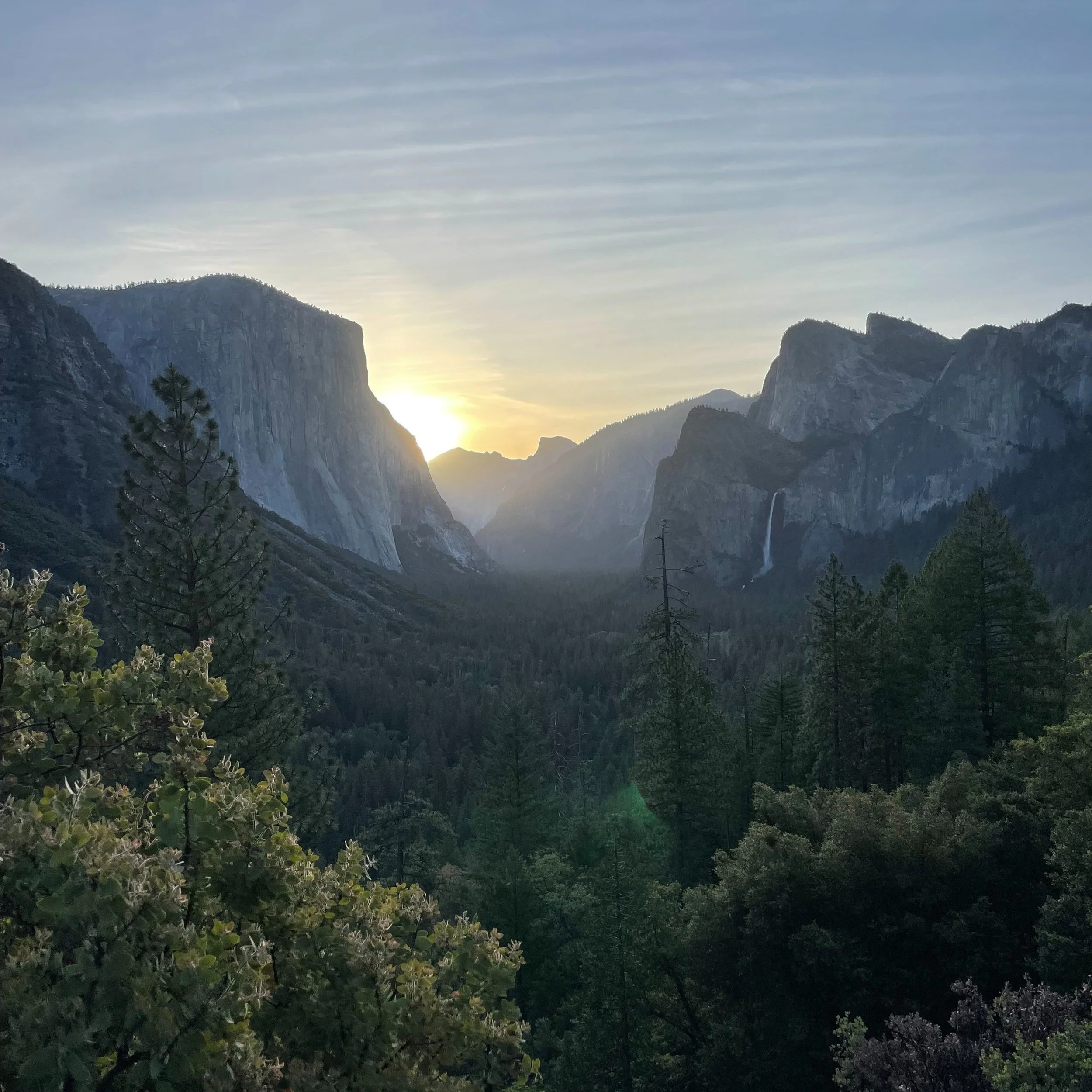
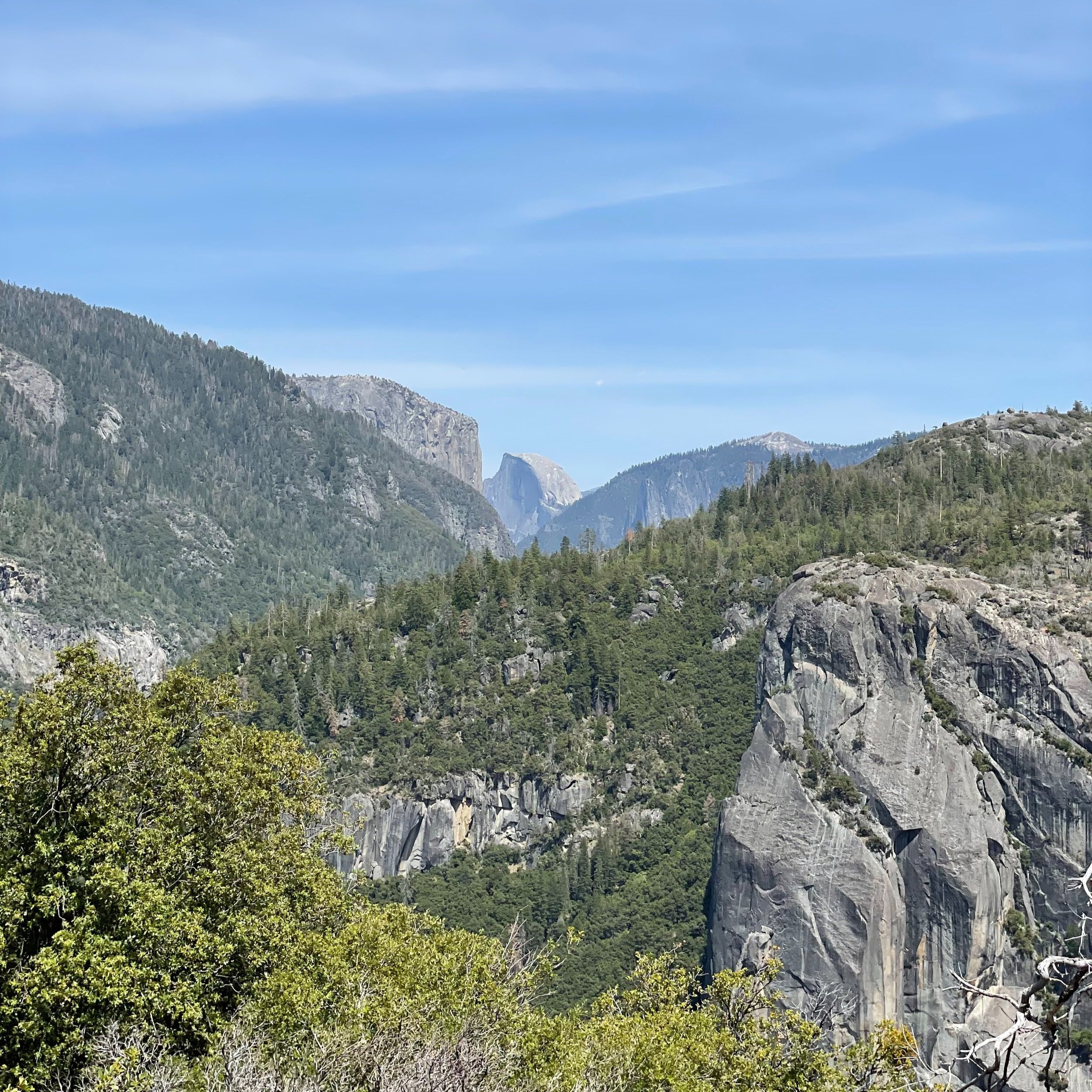
Tunnel View
Hiking in Yosemite:
There are two viewpoints I would recommend that are not hikes, but rather areas to park and enjoy the view:
Tunnel View on Wawona Road is the classic Yosemite viewpoint as you enter Yosemite Valley. Here you can see El Capitan, Horsetail Fall, Clouds Rest, Half Dome, Sentinel Rock, Cathedral Rocks and Bridalveil Fall.
Yosemite Valley Viewpoint on Big Oak Flat Road is essentially the other side of Tunnel View across the park with great views of Half Dome.
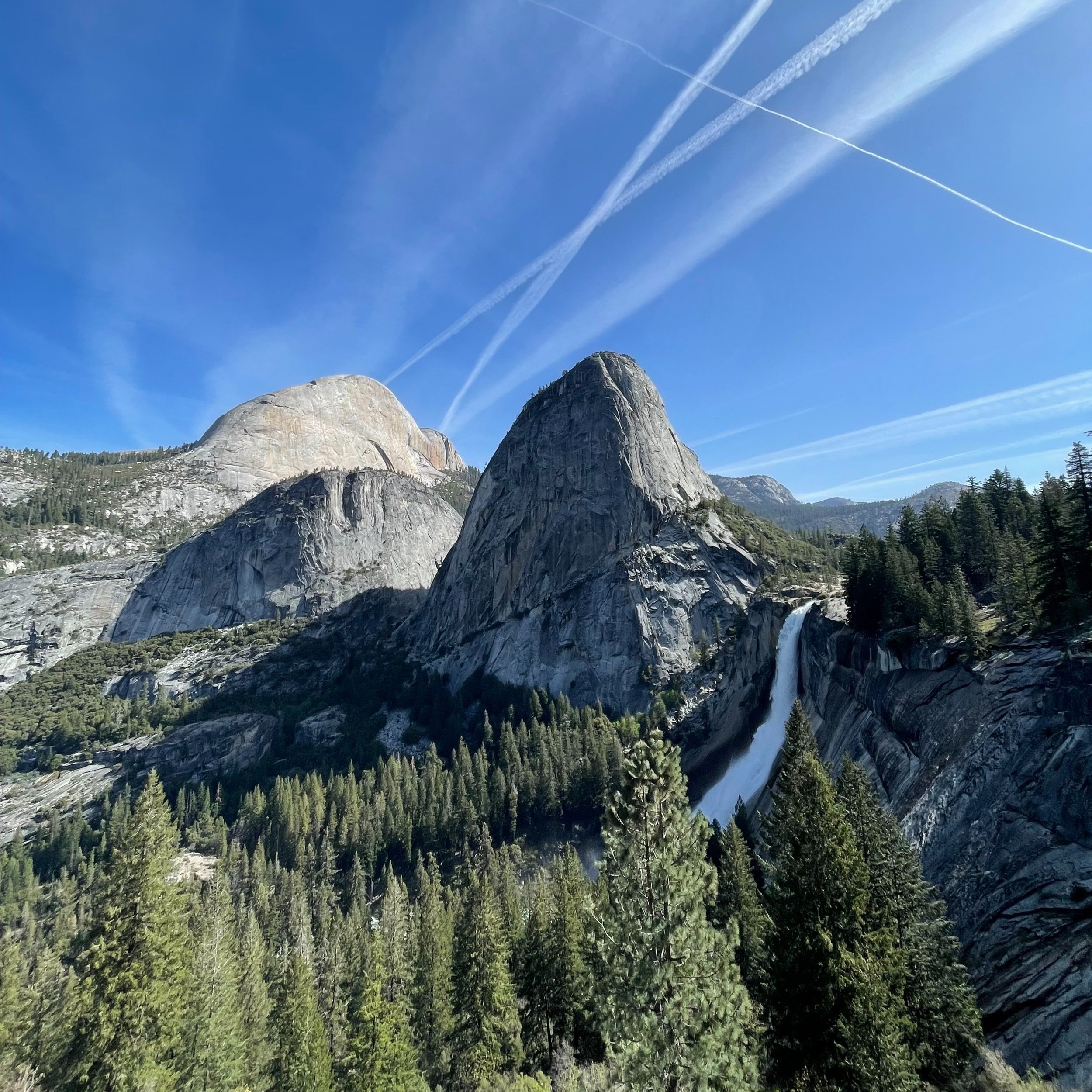
Vernal and Nevada Falls via Mist Trail
Vernal and Nevada Falls via Mist Trail
This trail is 7.2 miles long from the trailhead, 164 flights up with 2,162 feet of elevation gain, and is rated as hard. Keep in mind the closest parking lot is an additional 0.7 miles away. You can also take the shuttle to the stop near the trailhead.
The first section is paved and uphill and leads to the Vernal Falls footbridge. This is the most popular area of the trail as most people make it to the footbridge and turn around. There is a bathroom here and a water refill station as well. It is 0.9 miles/36 flights up from the trailhead to the footbridge.
Next you will come to Vernal Falls itself, where you should expect to get quite wet from the waterfall mist. This section has steep, wet steps and you will walk directly next to the waterfall.
From here you will continue up more stairs to the top of Vernal Falls before heading deeper into the wilderness. Next you will hike alongside Nevada Falls for a while, with great views and frequent switchbacks.
When you have finally reached the summit at the top of Nevada Falls there is an outhouse if you need it and great views of the valley below. As you start your descent there are great views of Half Dome, Nevada Falls and Mount Broderick.
At Clark Point you will have one last great view before taking the John Muir trail back down. There are quite a few switchbacks until you reconnect with the Mist Trail at the Vernal Falls footbridge.
Overall this hike took me 4 hours with lots of stops for photos and was a fantastic trail. It was not very crowded which was one of my concerns with it being in Yosemite Valley itself, but the difficulty of the trail means less folks are on it, and again I would emphasize starting early.

Mirror Lake
Mirror Lake Trail
Mirror Lake shares a trailhead with the Vernal and Nevada Falls trail, so I would recommend doing this after you finish your long hike as it is short and easy. If you are not hiking the Vernal and Nevada Falls trail, Mirror Lake is shuttle stop #17.
The Mirror Lake Trail has two sides—the left hand side is paved, the right hand side is not paved and has slightly more incline. On either side you walk along the water to Mirror Lake which has crystal clear water providing great reflections of the surrounding mountains. You also have nice views of Half Dome.
As an easy hike in the Valley, this trail and area in general is quite crowded. From the trailhead shared with Vernal and Nevada Falls the Mirror Lake trail is 2.6 miles total out and back and 12 flights up.

Lower Yosemite Falls
Lower Yosemite Falls
This is another easy and popular trail in Yosemite Valley with great views. It is a flat, paved 1.1 mile loop that takes about 30 minutes with stops for photos.
The trail leads to the base of the Lower Yosemite Falls which is crowded, but still beautiful. You can also see the Upper Yosemite Falls at certain angles throughout the trail, so be sure to look up!

Wapama Falls
Wapama Falls Trail
This trail is in the Hetch Hetchy area of Yosemite National Park. This area is only open from 8am to 5pm unless you are camping. There is a locked gate that a park ranger will come open at 8am and then you can drive through the park entrance gate to the trailhead.
This trail is 4.8 miles long, 38 flights up over 1000 feet of elevation, and is rated as moderate. It took me 2 hours and 15 minutes with lots of stops for photos. The trail is extremely quiet, especially compared to any trail in Yosemite Valley. You are exposed in the sun for most of the hike, so be sure to plan accordingly.
To start, you will cross over the massive O'Shaughnessy Dam, which provides water to the San Francisco Bay area. From here you will hike towards Wapama Falls with great views of the Hetch Hetchy Reservoir. There is also one smaller waterfall first that is higher up, so be sure to keep your eyes peeled.
Wapama Falls is absolutely roaring in the late spring and you will get soaked if you walk on the bridges under the falls.

Tuolumne Grove
Tuolumne Grove Trail
This is a 2.5 mile long, 22 flights up over 656 feet of elevation gain, and is rated as moderate. This is a paved trail that is downhill to the giant sequoia trees and uphill on the way back.
It is a quiet trail overall but still touristy since it is pretty accessible, but the hike back up is quiet steep. Overall I wasn’t super impressed, the giant sequoias are giant, but it was pretty boring and not really worth the time spent.
Valley View Point
Where to stay when visiting Yosemite:
You can choose to stay in Yosemite National Park or outside of the park itself, just depending on what you are looking for and what makes the most sense for you. It also will depend on where you are coming from—East, West, North, or South.
If you plan to stay in the park be sure to book your reservation far in advance—I would suggest 8 months to a year out just depending on when you are going. If you wait until even 6 months out all of the lodges are booked solid. Reservations open 366 days in advance and can be booked here. There are both hotels/lodges and campsites available in the park.
Personally I chose to stay outside of the park because of scheduling, pricing, and activities after hiking—if you are in the park you are a bit confined to the food/drink/activities there and I like to explore. I also was coming from Santa Cruz so the South entrance was closest and therefore I chose to stay in Oakhurst.

Bass Lake
Oakhurst recommendations:
The Yosemite Southgate Hotel and Suites is a newly remodeled hotel with clean and spacious rooms. They have a pool, hot tub and continental breakfast. It is 22 minutes from the hotel to the South Gate entrance of Yosemite.
South Gate Brewing Company in Oakhurst has a full food menu and solid beers. It is a great spot to visit after a day of hiking for tasty food and a cold beverage. They also have a small outdoor space.
Bass Lake is another spot worth checking out while in the south Yosemite area. This lake is nestled in Sierra National Forest and is a nice spot to relax after a day of hiking.
The Willow Cove trail is a short .7 mile out and back trail to a private beach on the lake. It is overgrown, rarely used, and full of bugs, but the spot it leads to is the perfect place to relax on the lake.
Ducey’s On The Lake is a nice restaurant with great service. They do not have any draft beer as a forewarning. They also have an upstairs patio bar/restaurant with great views, but it has limited hours.